Why Towns Follow River Valleys
Why towns follow river valleys becomes clearer when you compare slopes, crossings and routes, helping you read settlement patterns without mistaking clues for proof.
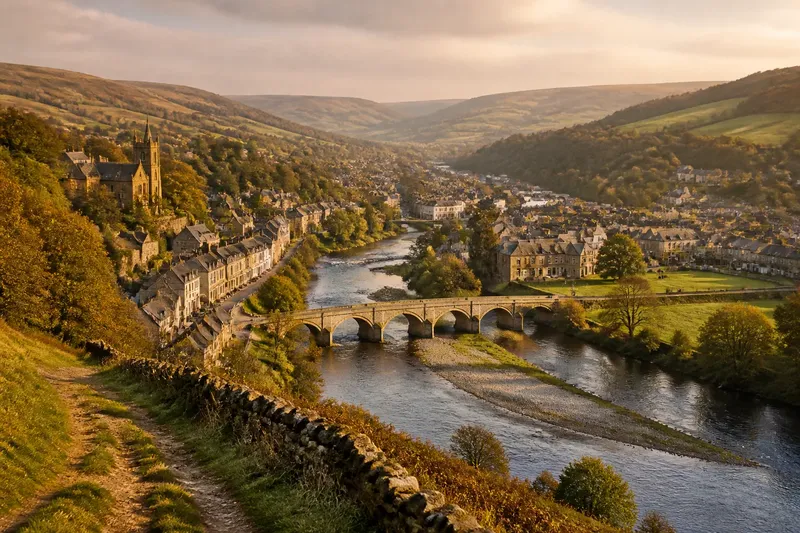
The common mistake when reading why towns follow river valleys is to assume the river explains the town’s whole shape. It may account for a line of houses or the position of a crossing, but that assumption can hide the effects of slopes, floodwater, older routes and neighbouring settlements. The valley offers choices; it does not make them on the town’s behalf.
Start with the landform, then compare it with streets, crossings and routes. The match can suggest how a settlement uses its setting, but it cannot by itself explain when or why the town grew.
Valley floors leave more room in some places than others
In a narrow valley, relatively level ground beside the river may be the most convenient space for buildings, fields and movement. Hillsides rise close by, leaving little alternative. A settlement can therefore stretch along the valley floor without sitting directly beside the water.
Contour lines help distinguish a broad floor from a narrow strip of low ground. Where the valley narrows, buildings may gather on a shelf, at a bend in the slope or on a terrace above the channel. A gentle rise or break in slope can mark a more suitable building surface than the river’s immediate edge.
On the map, note where contour lines spread apart and where they bunch together. In the landscape, compare the flat ground with nearby rises. “Near the river” does not necessarily mean “on the lowest ground”.
Floodplain edges can separate buildings from the river
Rivers can alter their channels and spread over adjacent low ground. Fields, open space, recreation areas or older industrial sites may occupy this floodplain, while homes and shops cluster on slightly higher ground at its edge. From a map, that arrangement can look like a town avoiding the river, when it may instead reflect the levels available.
Say you are comparing two map views of an invented town. The first shows a narrow river and streets along a raised strip; the second adds contour lines and reveals a low, flat area beside the channel. If the streets gather beyond that low area, the maps suggest a distinction between higher building ground and the floodplain. They do not establish local flood risk; for that, consult authoritative local information or a qualified professional.
Crossings bring routes together
A valley guides movement along its length, while a river crossing connects routes on opposite banks. A bridge or ford may draw streets and later development towards it, giving the town a centre organised around both the river and the crossing.
The approaches matter as much as the crossing itself. A narrower channel, firm ground or a gap between steep slopes may make one site easier to reach than another. Follow roads from both ends of a bridge: if they arrive from different directions, the crossing may link valley routes or connect the valley with a nearby pass.
A settlement near that junction may have a compact centre, with buildings strung out along the valley beyond it. The bridge is a useful clue, not a complete account of the town’s origins.
Side valleys connect the main valley to higher ground
Smaller valleys enter the main valley from the surrounding hills, bringing streams, paths and roads from neighbouring districts. Their junctions can provide access to higher ground. A settlement may grow near a tributary mouth or where a route climbing a side valley reaches the floor.
Trace the smaller watercourses on a map and compare them with roads, bridges, railways and older street patterns. Where a road follows a side valley, it may have found a gentler way down to the main route. That alignment is evidence of access, not proof that terrain alone determined the settlement: trade, political choices and transport changes may also have mattered.
Valley shape influences the town’s outline
A steep, confined valley often channels roads and buildings into a narrow band. A broad valley can accommodate several routes and more widely spaced neighbourhoods. In a winding valley, streets may bend around slopes, while open ground occupies low land near the river.
These are tendencies, not fixed forms. Two settlements in similar terrain can differ because one has a major route, an industry or an administrative role that the other lacks. A valley is more like a coat rack than a blueprint: it offers places to hang things, but does not decide what arrives or how it is arranged.
Routes show what the valley connects
Follow roads beyond the built-up area. One may run along the valley to avoid steep slopes, then climb through a pass. Another may cross a ridge or connect with a larger settlement downstream. The town may be a gateway between regions, a stopping point on a through-route or a local centre serving nearby communities.
Compare roads with railways, canals and paths where they appear together. They may share the valley corridor without following the same line: one route might stay close to the river, while another uses higher ground to avoid bends or low-lying land. Their different alignments can reflect different needs, such as a level gradient, access to water or a direct connection between places.
A straight line on a map is a poor guide to the actual route. Trace bends, junctions and approaches instead of assuming that the valley’s long axis explains every journey.
History can complicate the apparent logic
Landform influences where movement and construction are convenient, but it does not decide which location becomes important. A settlement may grow around a crossing, a religious centre, a market or a source of work. Later industry, transport changes and administrative decisions can expand it in directions the valley’s shape alone would not predict.
Look for layers of evidence: an older street core, a bridge, a railway alignment and a newer road may belong to different periods of growth. Current maps show the present arrangement, not a complete account of how it arose. Historical maps, planning records and reliable local sources can help establish the sequence.
Which clues explain a town’s position in a valley?
Why are some valley towns long and narrow?
Steep valley sides can leave only a limited strip of relatively level ground for streets and buildings. A town may extend along that strip, while a crossing or side valley can create a wider centre.
Why might a town stand above its river?
A terrace or hillside may offer a more suitable building site than the lowest ground beside the channel. Higher ground can also connect more easily with routes climbing out of the valley.
Does a river crossing explain where a town began?
A crossing can be an important clue, especially where routes converge at a bridge or ford. It does not establish a town’s origin on its own; other local and historical evidence is needed.
How can I read a valley settlement on a map?
Compare the river, contour lines, built-up area, crossings and routes into side valleys. Notice where buildings cluster or stop, then consider whether slopes, low ground or access could help explain the pattern.
Check several map clues before drawing a conclusion
Use an appropriate map and inspect these features in turn. Each observation should lead to a choice about what to examine next, not an instant verdict about why the town developed.
- Observe whether contour lines leave a broad, level valley floor; if they do, compare the settlement with that open ground, but if they bunch tightly, look for a terrace or shelf instead.
- Observe whether buildings occupy low ground beside the river; if they do, consult authoritative local flood information before making claims about risk, but if they sit higher, compare their position with terraces and slopes.
- Observe where bridges or fords connect roads; if routes converge there, inspect the junction as a possible focus of movement, but if they do not, look for another crossing or route meeting point.
- Observe whether a road follows a tributary valley; if it does, trace its route towards higher ground, but if it does not, check whether a ridge gap or pass offers another connection.
- Observe whether railway lines, roads and paths share one corridor; if they do, compare their junctions, but if their alignments differ, consider whether they serve different routes or terrain.
- Observe whether the street pattern bends with the river or slope; if it does, compare its shape with the landform, but if it does not, check for a later road, industrial site or other historical influence.
Imagine an invented town with these labelled map observations: a narrow river, tightly spaced contours on its northern bank, a flat strip on the southern bank, a bridge where two roads meet, and a smaller stream entering near the bridge. First, the northern contours suggest little level building space there, so you look more closely at the southern strip. Second, its low position makes it necessary to distinguish floodplain from terrace, so you check the contour pattern rather than assume it is safe or unsafe. Third, the converging roads make the bridge a likely movement junction, while the stream marks access to a side valley. The resulting reading is that terrain and routes together help explain the town’s shape; the map alone still cannot establish which feature came first or why the settlement became important.
Maps can be incomplete or use different scales. A modern road may cover an older route, while later development can obscure the original settlement edge. Compare map layers and local records where the sequence matters, and treat resemblance as a clue rather than proof.
For anyone asking why towns follow river valleys, the useful answer is layered: valleys shape available ground and movement, while crossings, routes and human decisions determine how those opportunities are used. Check the higher ground and the roads leaving the valley as well; they often explain what the river cannot.